Loop Backpack including the Southernmost section of High Sierra Route, connecting to the John Muir Trail and looping back to trailhead via Bubbs Creek Trail. Strenuous backpack of 66.6 miles total, approx 25 miles off trail, 18,009 feet elev gain (18,009 elev loss of course too)
When people start hiking off trail by map and compass, just about anything can and probably does go wrong that can possibly go wrong. By the time Gary and I decided to hike the southernmost section of the High Sierra Route, including about 25 miles off trail, we had had quite a few short sections of off trail hiking under our belts. Understandably smug in our ability to take on an undertaking of this magnitude, due to our experience, we were not prepared to be humbled quite so much by this journey. In retrospect, we can now both laugh at our audicity in feeling so over confident back then....at the time of this journey, we were quite chagrined at discovering the pitiful reality of our then compass and map reading skills.
The book,
The Sierra High Route: Traversing Timberline Country
is the brainchild of Steve Roper, an old time Sierra hiker that came up with the idea of paralleling the John Muir Trail. Steve had decided that the famous John Muir Trail was not quite as spectacular as it could be as it dropped from the crest of the High Sierra range and often took it's travelers in lower less spectacular areas. The High Sierra Route as proposed by Steve Roper remedied that lack and took those hardy souls capable of navigating through extended off trail travel in the mountains into higher, far less traveled, and much more phenomenal country than it's cousin, the JMT.
As I look back on the original map of this journey, I see handwriting smeared by sweat, pictures taken by the handful of backpackers who at that time had broken trail before us painstakingly researched and pasted onto the map. I see the map is creased and recreased from the many folds as we refolded the map during our journey over and over while keeping the section we were currently navigating visible thru our baggie. Almost every fold has been shredded by use allowing long gaping holes to puncture our precious guide. I also see the hours we spent poring over the contour lines picking the best way over each ridge and around each lake. I see yellow highlighter fading with time that once stared brightly back from the face of a once sparkly clean map. Our highlighted route now lying dully smudged by the high Sierra dirt soiling the surface of the map. I also see the consternation on Gary's face as we stand on the edge of a precipice looking a thousand feet down into the canyon that should have been a near vertical cliff face in front of us.
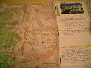 |
| Our original map |
That canyon was near the beginning of our 9 day journey and a humbling start of the many off trail miles still to be navigated in the next few days!
There are many reasons why backpackers head to the backcountry to hike. Number one I suppose is the beckoning of the beauty of the wildflowers, views and wildlife to be experienced that are really not available any other way than by donning a pack and paying your dues of blood, sweat and tears in the wilds. Another reason for extended hikes is the feeling of accomplishment of miles hiked, trails traveled and earning the knowledge that you can live for an extended period of time with nothing more than what you can carry on your back. And last but not least, is the ability to experience nature on her own terms. And not that I am anti-social, as I am not, but....that last reason to backpack is best experienced without the hordes of people you find in cities and towns. Backpackers seek lesser traveled trails for that brief period of time they have to live in nature. And, off trail is the best of that world. So, for all of the above reasons, Gary and I decided to spend the better part of a week of our 9 day backpack in Aug of 2000 off trail in the High Sierra.
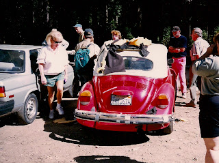
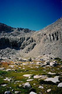
The choice of the southernmost part of the High Sierra Route was obvious for us simply for the reason that we had not hiked it before. Most backpackers go to great lengths to find places to travel that they've never been to before, and Gary and I had hiked very little in the area we were about to journey. So, after making our maps at home and packing, we headed off to the Copper Creek Trailhead in Kings Canyon National Park. Our first night's camp was at Tent Meadows. There are lower and upper tent meadows, and for any backpackers reading this....you have two choices for a first night. Either you stay at Lower Tent Meadows on the way up to the Crest, I think about 4 miles, and sleep on a slope in the trees in a well used camp spot. We did share our night at Lower Tent Meadows with a huge herd of deer whose youngsters were galloping around and playing for a couple of hours nearby. Or, you climb close to 5,000 feet in one day to get up to the Crest. I've done both....I would opt for the Crest were I to do it again probably....but that is one nasty first day! If you opt for Lower Tent Meadows, you then get half the climb, and will look forward to a choice of lovely campsites for your next night....Grouse Lake, Granite Lake...or anyplace beyond.
Staying at Lower Tent Meadows, our first day was entirely on trail of course. And following Secor's book closely the next day (I had actually taped photocopies of certain pages to the back of my map), we really had no major problems finding our landmarks. Notice the use of the word major. Grin. Once the Copper Creek trail leveled out, we knew Grouse Lake would be just North of us. We went for the suggested half mile, and found no creek, no lake, no water. Maps don't lie however, so we knew the direction we had to go to find the lake. And we had to find the lake, as the "trail" we wanted would climb out of the lake bowl up a ridge....without finding that lake, we would not have the ability to take the next leg of our journey. Eyeballing a ridge and dense forest to the north of us where the lake was supposed to be, Gary suggested we climb the ridge above the trees to get a better view. Surely we'd be able to see the lake from the top of the hundred foot ridge in front of us. As we climbed, I started realizing this was a bad idea. We were getting higher and higher, and still no lake view. Gary had pulled ahead of me, and was almost out of sight. But finally, I heard his yell.... "I see water!" Once down at the lakeshore, we were quite chagrined to realize we could simply have walked through the forest and obtained the lakeshore...hindsight is always 20/20!
Water in the backcountry is generally a welcome sight, but when your navigation depends on finding it, it is downright exhilarating! Excited about navigating our first hurdle, and enjoying a light snack at Grouse, nevertheless, we bemoaned the fact that we hadn't climbed all the way to it the first day and spent our first night there. That was the seed that was planted encouraging us to later climb all 5,000 feet in one day in a later trip! Ultimately though, we congratulated ourselves on a job well done in finding this hidden lake...and our route out. For, the next leg of the route would take us straight up the lake bowl to the North side of the Lake to the top of 11,320 ft Grouse Lake Pass or Grouse Lake Saddle. Picking our way fairly easily up and around chunks of granite to the top of the pass took awhile, but we finally allowed ourselves the luxury of stopping for a leisurely lunch in the sun once on top. Taking in the outstanding views, we saw a series of three tiny tarns west of the pass, most definately a great place to stop for our next night. So we made our way to the tarns and had lovely views back down canyon onto unvisited Granite Basin, a sneak preview of a spot we'd visit in a later trip.
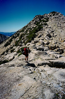
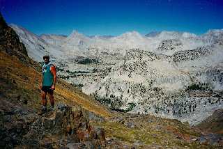
 |
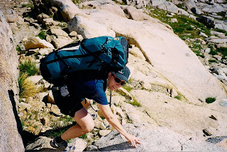
Dee atop Goat Crest
In the early morning sun, we regained our route, and were soon at the top of Goat Crest Pass.
Then started the downhill work. Sounds a little odd to call downhill climbing work, but as any off route hiker knows, those steep talus fields can be agonizinly slow and hard on the "brake" muscles! |
 |
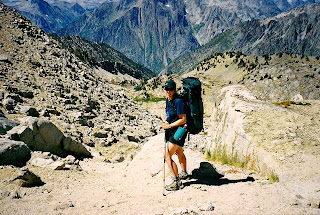
| Dee Down climbing from Goat Crest in a heavier pack than she'd have in a few days, and certainly heavier than she'd use in later trips! Off trail hiking makes you want to shed those pounds! |
Towards the bottom though, the "climbing" got much easier and we "strolled" down to Glacier Lake.
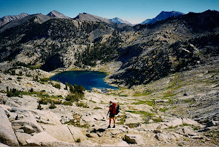 |
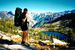
| Gary strolling down to Glacier Lake |
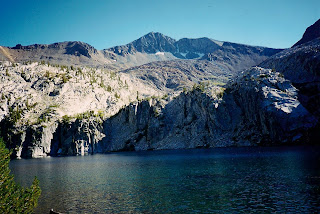
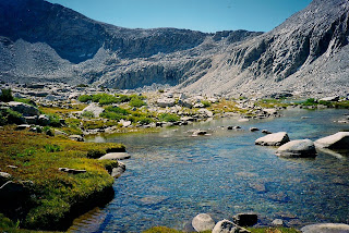
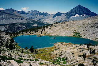
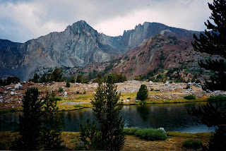
Glacier Lake was lovely with a nice sandy beach to explore and enjoy....snack time again.
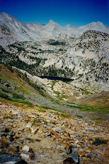
 |
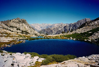
| Glacier Lake is the quintessential "High Mountain Lake"...notice the distant peaks just slightly higher than the lake level! |
Being so early in the day though, we couldn't justify staying a night there so we begrudgingly left the beach and headed on down valley There was one point at which the guide book had said to veer a certain direction. Looking impassable, we chose to veer the other way. We ended up doing some pretty serious bushwhacking and learned to follow Steve Roper's advice! Finally though, passing another of the Glacier Lakes, we obtained lower Glacier Valley at about 9,900 feet and found ourselves in the trees, and for a couple short miles actually walking a real trail again briefly!
Sauntering on a trail was a pleasant diversion from our off trail boulder hopping, bushwhacking and steep ups and downs. We strolled to and around first State Lakes, and then trailless once again, made our way to Horseshoe Lakes which were quite easy to find.
From Horseshoe Lakes our real navigation began in earnest. The previous off trail was just a warm up. From Horseshoe Lakes we'd be going over 4 passes with no trail, Gray, White, Red and Cartridge Passes and be exploring miles of drainages and basins and lakes on our way back to any signs of civilization. Thus, it was rather disconcerting as we hiked away from Horseshoe Lakes presumably to hike up a 1,000 foot cliff face, that we could see no cliffs in front of us through the trees. However, there was no mistaking we were at Horseshoe Lakes....their shapes so distinctive on our map, that they might as well have had a trail sign by them. So, we just kept going in the direction our compass and directions said to go and took it on faith that the cliff would present itself sooner or later. We did do some climbing....about 300 feet up a gentle slope. But, not the vertical cliff face we searched for. Both of us were starting to get more than a little concerned, for when you are off trail you depend heavily on landmarks like cliff faces to let you know you are going the right way. Finally though, late afternoon was upon us, meaning we had traveled the necessary distance to have gone beyond the cliff face, and we had advanced as high as we could go. Standing on a barren lonely plateau with far reaching views in almost every direction, it was clearly obvious something was quite wrong! Standing on the edge of a steep precipice, suddenly it hit me! I started laughing... and to this day don't know how I managed to get the words out to tell Gary what I had done. For it was I who had researched and planned the route and studied the map so closely and knew the cliff should have been where we stood. When Gary came and stood next to me, looking at me quizzically, I pointed at the map, and then pointed down at our feet. For far below us directly under our feet, was the missing 1,000 cliff. We stood with our toes pointed over a 1,000 foot precipitous drop off into Windy Canyon. My cliff face was 1,000 foot vertical drop, not a 1,000 foot climb up! Those squiggly contour lines do not tell all. We learned that day that you must look at the tiny little elevation numbers to know whether those lines are taking you up or down! Both Gary and I were quite chagrined as he had studied the map as frequently as I had all that afternoon while we searched to find our way. As it turned out though, following compass alone, at least we had correctly found ourselves on Windy Ridge exactly where we needed to be! Finding a lovely little tarn on that ridgetop, we pulled out our gear and enjoyed a wonderful camp and an unobstructed starry sky that night.
 |
| Camp atop Windy Pass |
Many fellow backpackers wouldn't dream of sleeping outside without their tent. Gary and I relish sleeping sans tent. There is nothing quite like the gentle night breezes soughing across your face, or waking up in the middle of the night cozy and warm while snuggled in your fluffy down bags as you watch the meteors streak across the night sky. In fact, most folks don't realize just how many shooting stars streak over their heads undetected every single night. On an average, while in the high country of the mountains with no city lights to damage the view, we probably see a shooting star every 2-3 minutes all night long! Sleeping outside under a starry sky is half the wilderness experience for me. Unless it's raining or it's early season and the mosquitos are driving us mad, we sleep out under the wide open night sky enjoying the thick blanketing of stars normally not visible in town.
Come morning, well rested after a cozy night on Windy Ridge...which had just enough wind to lightly blow the mosquitos away...we packed up and headed towards our next landmark. For that is how one hikes off trail, from landmark to landmark. And, we soaked in some lovely views as we made our way the length of the ridge.
We took turns guessing at which way we'd be making our way down from the ridge. As it turns out, neither of us were correct as the landscape herded us into a narrow hidden defile next to the cliffs we had been flanking. As we oohed and ahed over the ingenuity of those who had passed before us, we were astounded at what they had accomplished. For in 1935 the Sierra Club had brought about 100 people this way along with enough stock to supply those folks on one of the largest backcountry expeditions of the Sierra Nevada the Sierra Club ever accomplished. Only by traveling in their "footsteps" can one truly appreciate the magnitude of their feat. Once off the easy traveling Windy Ridge, there were times when Gary had to lend me a hand, and even take my pack and boost it up before I could get up an occasional little cliff face. And being an owner of a very agile horse, yet I cannot imagine getting my horse down some of the huge skirts of granite several feet high those early travelers got their stock down and up. These early travelers had to spend extra time laboriously building sections of trail to safely get their stock through. The care and patience and creativity they had to have had to travel where we were traveling was mind boggling to us. And a couple of times we benefited from tiny pieces of trail still existing that they had engineered back in 1935.
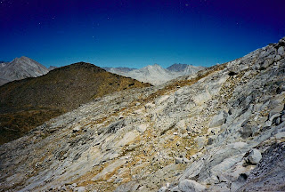
Soon off of Windy Ridge though, we worked our way down to the South Fork of Cartridge Creek. A sample of some of the material I found about this area's traveling:
"The route drops down into the South Fork of Cartridge Creek. Follow the stream up until a small lake about 10,500 is reached. From here, veer left up to a series of smaller lakes under Marion Peak." That sounds so easy from the comfort of home. Once you are "out there" however, reality is much different. Every few minutes as you climb with sweat forming under your hat brow and formimg rivulets down the sides of your face, you wonder how far you are to climb. Was that little mosquito pond you passed 10 minutes ago the pond the previous hiker was talking about? If you have an altimeter, are you calculating the inevitable errors of your altimeter correctly? My husband's altimeter seems to lose or gain 60 or 80 feet every thousand feet. At each landmark you find, your spirits are buoyed immeasurably. You are found! Then as you make your way to the next landmark, doubts assail you unmercifully. Just one or two in the beginning...."hey, can I look at the map again real quick?" Then if you don't find your next landmark as soon as you thought you should the doubts start crescendoing upon you. Until finally, one or both of you calls a halt to regroup and really restudy the map. We did however successfully find that pond at 10,500 feet this trip and climb up a rocky gully past a series of tarns enroute to Gray Pass. The hiking was relatively easy for quite some time as we climbed from granite bench to granite bench. Eventually we did come to Gray Pass and enjoyed the wonderful views and exhilarating feeling of knowing exactly where we were!
 |
| Looking back at Gray Pass....obvious Gray Mountains! |
 |
| Dee quite tired from not eating enough! |
Our next landmark, White Pass, would cause us no little consternation however! Traveling from one pass to the next, sounded so easy at home. Go over a pass, walk down to the valley on the other side and climb up to the next pass. However, by the time we had passed over Gray Pass and taken the stroll down into the basin at the foot of Marion Peak....we realized there were a couple of obvious saddles ...and to be honest, we weren't one hundred percent certain we were even actually looking at Marion Peak! Gary was still going strong, I had not eaten enough and was flagging quite a bit. When you are backpacking, it is very wise to carry snacks handy in an easily
accessible pocket and actually eat a bit every 90 minutes or so to keep up your pace! I had not done that and was mentally, emotionally and physically drained! Worried about our navigation and getting lost on top of being tired and hungry was a bad combination. As I was rapidly approaching meltdown status, Gary had me take off my pack, sit at the bottom of the basin studying my map....and eat! Meanwhile, he left his pack with me and was actually fresh enough to take off at a jog up to the top of what we possibly thought was the correct pass for a quick look around. The country around us being above treeline was quite wide open and so I could see him most of the time we were separated. All but when he was at the top of the pass...and had stepped to the far side of it. Each minute Gary was out of sight at that point was like an hour. When we separate in the backcountry, I am always quite concerned. By the time he came back in sight though, I had eaten enough to replenish my energy....and studied the map enough to be pretty sure the peak at my feet that rose high above my head was indeed Marion Peak. And by the time Gary returned he was able to confirm my map study. He had indeed actually climbed White Pass and verified we were on the right path. My rest was extended while Gary had his lunch, and then off we went to climb our next pass that day.
 |
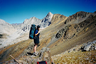
| Gary checking out the route ... |
 |
| Red Point with Red Pass on the right shoulder of the Point |
Once on top of White Pass, our next goal, Red Pass, was all too obvious as it would lie just south of the Red Peak in this picture. Elated at spotting Red Point and thinking it would be an easy stroll to the pass....off we went. And, the going was relatively easy. Walking on loose but gentle granite slabs and benches, we moved pretty quickly. One mishap occurred in that section that I have paid for dearly in later years though. We had come upon a granite shelf that necessitated we go over the top of it, rather than around. A pretty good vertical drop off at the edge of the granite block convinced us climbing over the top of it was the wiser and only choice really. So, Gary climbed up first. I was a little slower, placing my feet so as to be able to have enough leverage to give myself a boost up. Nevertheless, the ledge was just high enough that I just could not quite get myself up on the shelf without either taking off my pack and shoving it up ahead of me, or getting help from Gary. Gary was ready to help, so I stretched out my arm for him to grab. He grabbed and pulled, but our timing was off and because I was not quite ready to boost myself up at the same time that he pulled my arm, he very nearly dislocated my shoulder. In years since, we have never done that maneuver again without a verbal "one, two, three, go!" But, I squeezed the tears of pain away and kept walking.
 |
| Red Pass finally in view, still an hour's walk away.... |
 |
| Dee standing at the pass, notice the Granite in the background and the red metamorphic rock of Red Pass |
 |
| On the East side of Red Pass, notice Marion Lake just popping to view to the right of Gary's feet mid picture. |
 |
| Piece of trail bottom foreground |
On the East side of Red Pass enroute to Marion Lake, we were pleasantly surprised to find pieces of old trail guiding the way. This country was so lightly traveled when we first hiked it, that we presumed these little bits of trail were left over from the 1935 Sierra Club expedition rather than being "use trail" sections.
By now, the day was aging and thoughts of camp started popping up. We had one last hurdle to jump before being able to take our packs off for the night however. The dreaded Marion Lake chutes! Actually, since we hadn't been there yet, we didn't really dread them yet. We would in future trips though. Looking at the picture above, you can see Marion Lake mid picture, and see the lake is in a granite bowl with steep sides. As you approach Marion, it becomes more and more obvious that the side of the lake you are approaching presents nothing more than a sheer vertical drop of 50-100 feet into the lake! Almost. The steep granite skirt on the side of the lake we were approaching does however have several fingers lined with tiny talus and powder which you can see in the picture below. The instructions I remember finding, say to take the far left chute. Further, the instructions claim that the chute is not obvious and to go to the last obvious chute on the left, and then look for one more. In neither that trip, nor the following trip a few years later did we ever find "the easier" left chute. Taking what we thought was the correct left chute, Gary started down first and my heart was in my throat as I took the first tentative steps behind him. For at the top you are truly taking it on faith that the route is passable as all you see when you take those first steps is near vertical sand with water at the bottom! In fact, the reality is not much different from that! It is however, passable. From time to time I started sliding, but was able to halt my slides. And at one point as I slid into Gary I thought we were both goners, but he was able to both halt my slide and keep his feet. And, by the time we neared the bottom, we found we could actually bushwack around the granite chunk of cliff on our left and finally obtain the shoreline!
 |
| Marion Lake Chutes, Red Pass on the far top right |
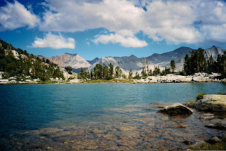
Marion Lake was not too shabby a camp for the night and we enjoyed exploring the area. Any tips for future hikers to the area, I probably would not camp there again. The only places to camp were just too close to the shoreline....and beautiful Lake Basin is just a hop, skip and a jump away anyway.
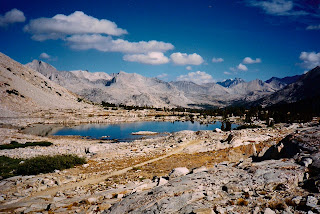
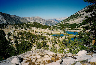 |
| First glimpse of Lake Basin |
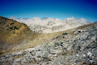
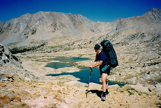
In the morning, we gleaned our first look at Lake Basin. We had seen Lake Basin on maps for years....but had never ventured there. Lake Basin is stunning. Early season wildflower displays must be simply stunning....nevertheless, even in August we felt we were still strolling through paradise! We took our time strolling through this lovely basin. Enjoying the many lakes dotting the landscape under the deep blue sky. We spied the route we'd be taking if we were to continue on the High Sierra Route North. Alas, that would be for another trip....we needed to loop back south and begin our journey back to the trailhead. Still several days of backcountry ahead of us though, and the rest of our off trail navigation ahead of us, Gary and I were discussing just where exactly we should be headed in Lake Basin to access Cartridge Pass. Deep in discussion, neither one of us at first noticed the movement across the Basin. Not sure which of us saw it first, nevertheless we both stopped and stared....what was coming towards us? A few long seconds passed before we realized it was another human! Having not seen a human in several days now, it took us quite by surprise! Another hardy hiker was picking his way in our direction. We would not pass close enough to say hi to him as we would be farther up valley by the time he made his way to our present location, and I'm not sure either of us wanted to! Normally backpackers are quite friendly and neighborly types. As you wander down a trail and pass another backpacker, you are sure to ask about the trail ahead and answer the same questions to the hiker going in the direction you just came from. Here in Lake Basin though, after having had the wilderness to ourselves for days, it was actually quite an intrusion to find another hiker in "our" valley. I am sure the other hiker felt the same as he never lifted his head to gaze at us much less lift an arm to wave. We all just simply quietly passed as ships in the night enroute to our respective destinations. Gary and I have since been back to Lake Basin, in fact we have hiked this section of the High Sierra Route again, and I am sorry to say word had gotten out and we maybe encountered 25-30 people taking this same journey. I am glad that so many are able to enjoy the wilds as we do, but it most definately is a different journey when you travel to high, wild places that not too many others have discovered yet, and I'm glad we got to experience it when spotting one single person was a huge surprise!
 |
| V Lake. Red Pass on back right is where we came from |
 |
| Distances are deceiving....notice Gary strolling along at the base of the cliffs! |
As we made our way to the highest lake in the Basin, our first glimpses of the cliffs Cartridge Pass were to go over gave us both not a little trepidation for what we were about to attempt!
 |
| Appearing very steep, our first glimpses of Cartridge were nervewracking! |
But, as neared the base of the cliffs, the pass appeared more and more doable. Heights in the backcountry always appear steeper from a distance! However, two words still could not be minimized on this steep several hundred foot climb...."loose rock." No other way to find out though how doable it was, than simply by doing it. So we proceeded to the base of the cliffs.
 |
| The finer looking talus lines in the cliffs across the water is Cartridge Pass |
Once we reached the base of the climb, I realized I needed to eat. At the bottom of a steep climb however, is not when you want to fill what will turn to a chunk of lead in your stomache during a workout. So, I satisfied myself with a couple of pieces of dried fruit to sustain me for the climb. As we started out, I quickly realized this was not a climb I wanted to look down on. Being afraid of heights means you can climb anything as long as you don't look down! And though Cartridge is not really what you would call "exposed," meaning you are not in danger of falling off the cliff face if you lean the wrong way, nevertheless, the climb is quite steep. My characteristic way of dealing with steep climbs is to scramble up as fast as I can. So, I just put my legs in gear and started climbing. Gary took up the rear in an effort to give me a false sense of security, bless his heart. Moving very rapidly, I just wanted to get it over with. No enjoying the views til I am safe on the top. But a pleasant surprise presented itself on this climb in the form of a nice little flat bench midway up the cliff!
 |
| Tired after a fast scramble up the pass, Dee rests on a little bench half way up Cartridge |
Having made "the halfway bench," the rest of the climb is less steep and less exposed and much more relaxing! From the top of Cartridge Pass we had wonderful views back on Lake Basin as well as views south to Arrow Peak, Bench Lake and across towards Pinchot Pass on the John Muir Trail.
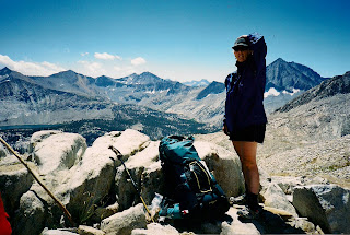 |
| Dee on Cartridge. Bench Lake mid left, Arrow Peak behind Dee |
Heading down Cartridge Pass we were once again reminded of the old Sierra Clubbers, and old time sheepherders as well, while we followed in their footsteps down an old narrow spotty piece of trail! The bits of trail were quite welcome even if they were steep and not very well engineered. This old trail managed to get a lot of pioneering folk down the steep canyon walls to the South Fork of the Kings River. This old forgotten trail also served Native Americans well as evidenced by the obsidian chips and arrowheads Gary and I found back on our journey. We left them where we found them so if any of my readers happens on to them also, please leave them for the next lucky hiker! In fact on this trip we found two spots where the Piutes had camped and made arrowheads while hunting or gathering or doing whatever else the backcountry afforded them on their journeys. Both the Piutes and the Mono Indians frequented the High Sierra and would meet in the Sierra to trade things like Salt for Obsidian.
Our next leg would take us down to the South Fork of the Kings River from which we would follow it's wandering path out to the John Muir Trail and find ourselves traveling a well marked route again. However, we were allowed one last backcountry slice of heaven to enjoy while off trail. A little lake part way down from Cartridge that we like to call Dee's lake. In otherwards, it has no name on a map. I am sure every off trail adventurer has special names for nameless lakes they find ....we have one for my daughter too, that she found for us one trip...but that's another story for later! Coming upon this particular lake, we realized how little time in the real backcountry we had left. Soon we'd be joining the hordes on the John Muir Trail. As we'd discover in the next couple of days though, there aren't that many out on the John Muir Highway either as it's frequently called...in reality we would see only a couple of folks on our way back to our car. We didn't know that at the time though and wanted to savor what true solitude we had left, so we actually took a half day off and set up camp a few hours before we normally would. Good choice on our part as this lovely little lake had just enough views to help us thoroughly enjoy the afternoon taking a cold water dip, reading and exploring. At night we had the most absolute flat spot to sleep on....ah heaven!
 |
| View of last lake before dropping down to the river, we followed the left shore and got to the outlet shown mid left of pic, and dropped off the edge of the world...and down about 1,200 ft to the river |
 |
| Not too shabby a place to spend our last "off trail" night. |
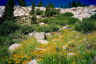 |
| Lovely hillside of Bigelow's Sneezeweed |
In the morning light, we packed up and headed on down to the South Fork of the Kings River. As we dropped off the cliff, we initially shared the trail with magnificent fields of Bigelow's Sneezeweed.
Then the "trail" got hot, dusty and steep as we crisscrossed down multiple switchbacks in the hillside. As it turns out, we had a bit longer than we thought til we hit trail. Not only did we have more elevation drop to negotiate getting down to the river, but once at the river, we encountered the dreaded talus fields. Any backpacker with any miles on their feet knows the term "talus field." Talus is large chunks of granite piled high and wide, oh my. Hopping from boulder to boulder, balancing on the balls of your feet, grabbing with your hands and hoisting yourself over huge boulders and slabs of granite, pack and all for hours at a time is not exactly fun. Well, in the beginning it is, but when you go for loooonnnngggg stretches of talus....then get through the dreaded field and in a few minute start another one....it's a lot of work. Getting from where you hit the river til you get out to the John Muir Trail gives you lots of practice on talus fields as you hit several large ones! Finally though, we came through the last talus field and were meandering through lightly forested flattish terrain following a faint use trail, when suddenly in front of me my path was blocked! Oh no, did I go the wrong way? I looked up quickly trying to puzzle out what someone was obviously trying to tell me, and realized the message was not for me...it was for travelers on the John Muir Trail, trying to keep them on the JMT and not sidetracked onto the "trail" I was on! Hallelujah! After over 25 miles of off trail travel, getting slightly lost at least once, climbing terrain fit only for a mountain goat at least once, misreading my topo map at least once and sliding almost out of control on steep loose scree while being somewhere I probably shouldn't have been at least once....we were back on a real marked trail!
 |
| See the faint use trail mid pic and the blockade keeping folks from sidetracking accidentally |
The rest of our trip was thankfully anticlimactic. It was wonderful being back on a marked trail. Not having to navigate constantly and search for landmarks and check map and compass every few minutes was incredibly relaxing. Of the 3-4 days we had left to hike, we enjoyed amazing views most every foot of the way back, extravagant pockets of wildflowers, and lovely well engineered maintained trails. No more routefinding mishaps, no more sliding down steep chutes trying not to fling off into space and drop into a lake pack and all, no more meltdowns caused by hunger and exhaustion, no more endless talus fields to wear us out. What we had instead was an incredible feeling of exhilaration for accomplishing all that we accomplished and a few days more to unwind and enjoy the comforts of trail hiking while still in the wilderness before we had to face the real challenges of being back in the rat race of traffic and deadlines.
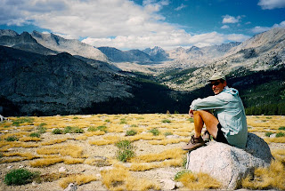 |
| Gary drinking in the view |
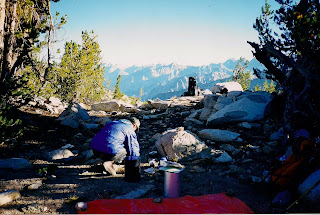
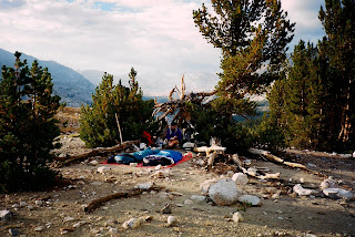 |
| Camping in a windbreak with fabulous views facing out |
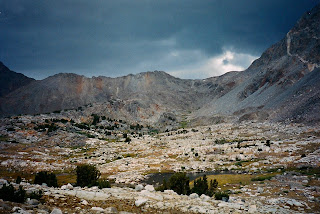
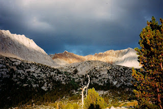 |
| Storm brewing that gave us a great show! |
 |
| A real trail to follow.... |
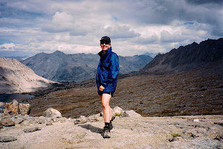 |
| Dee on Pinchot, happy to beat the storm over the pass |
 |
| Looking back at Pinchot and happy to be lower down |
 |
| Views every step of the way back |
 |
A well engineered trail....with a suspension bridge!
|
Hope you enjoyed reading this tale as much as I enjoyed writing it!